


Vintage Map of Northwest Africa by Lucien Boucher - 1950s
Vintage Map of Northwest Africa by Lucien Boucher - 1950s
Couldn't load pickup availability
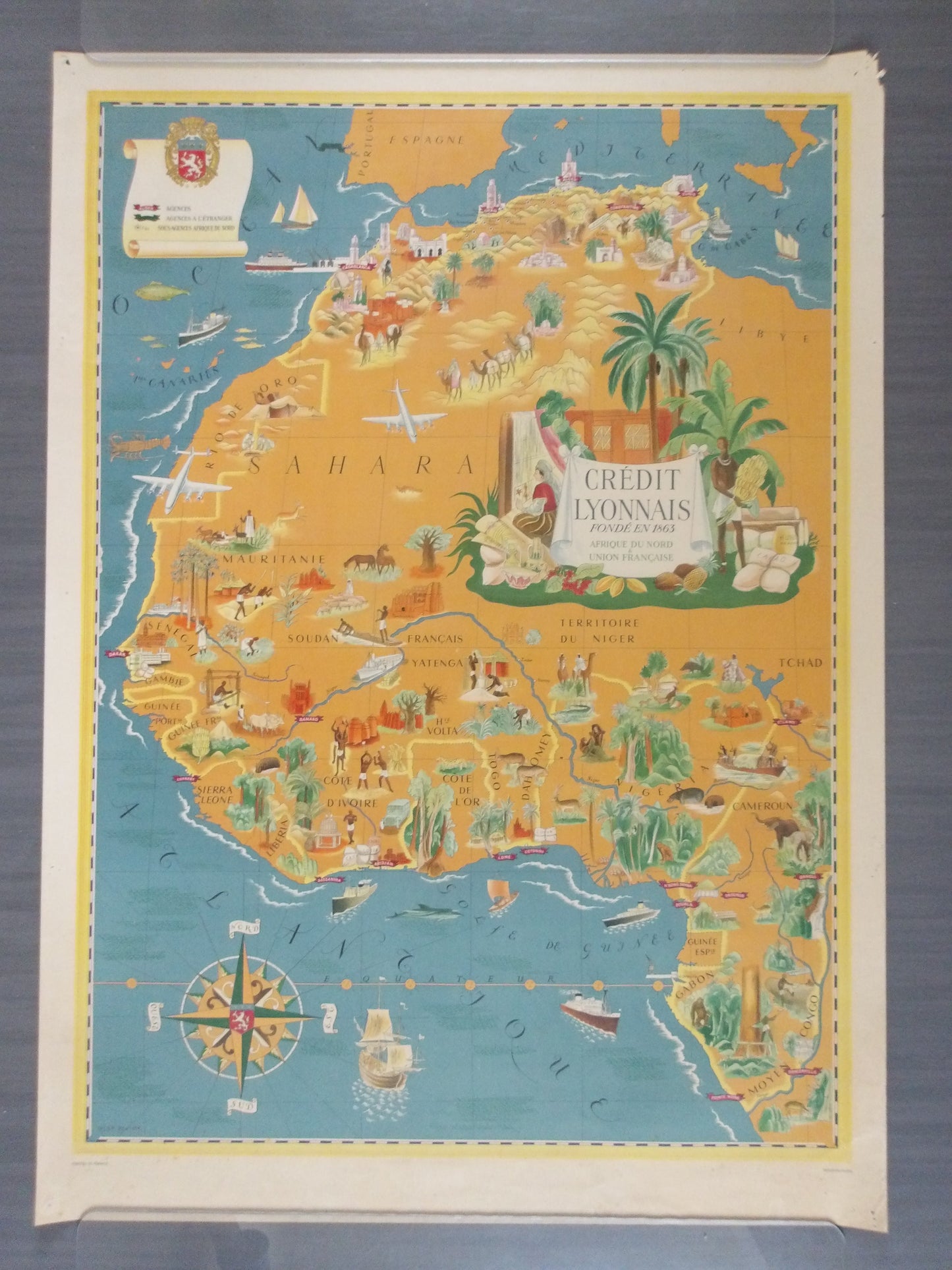
This beautiful illustrated map of Northwest Africa was designed by Lucien Boucher for the French bank Crédit Lyonnais. Published towards the end of World War II, the map presents an idyllic view of French colonial possessions in Africa at a crucial moment between Free France and decolonization. The map stretches from Tunis to the mouth of the Congo, with charming illustrations of the region's architecture, people, resources, and wildlife. The bank's main branches are located in several cities, including Tunis, Algiers, Casablanca, Dakar, Conakry, Lomé, Douala, and Pointe-Noire. An overseas branch is depicted in Lisbon, while secondary branches are identified throughout the Maghreb by small white stars. Much of the interior is dominated by a huge bank title/advertisement cartouche, which emphasizes the region's exports. Boats and sea creatures fill the waters. The composition also features a large ornate compass rose. Printed in Paris by Perceval.
69.3 x 95.5 cm
Boucher (1889-1971) was a French commercial artist inspired by the Surrealists. He regularly worked on cinema posters and other advertisements, but he is best known for his series of posters for Air France.
Condition :
Very good condition. A colorful example with minor foxing along the bottom edge, some toning along the edges of the sheet, and pinholes in the blank margins. Please note, my maps are old and not always in perfect condition! Shipped in a tube.
List of main places represented:
Mauritania, Senegal, Mali (French Sudan), Guinea, Ivory Coast, Burkina Faso (Upper Volta), Niger, Benin (Dahomey), Togo (French Togo), Ghana (Gold Coast), Nigeria, Cameroon, Chad, Central African Republic (Oubangui-Chari), Republic of Congo (Middle Congo), Gabon, Sahara, Libya, Algeria, Sierra Leone, Liberia


-

Secure payment
-

Careful shipping
-

No reproduction
-

Satisfied or refunded


-

“Hello, thank you for sending this, the cards are superb!”
Jean-Philippe
-
"They are very beautiful, just need to frame them! Thank you"
Baptiste
-
"Fast shipping and very good tracking."
Alice
-
"My husband loved the maps I gave him for Christmas!"
Solène
